Celestial navigation is the art of position fixing relying on the celestial bodies.
Preliminary
These lessons are limited to the necessary knowledge to use a sextant and Almicantarat software.
Altitudes
Celestial navigation relies on sights and time measurement.
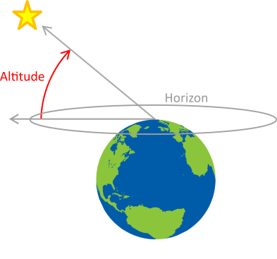
Altitude is the angle between a celestial body and the visible horizon. The angle is measured using a sextant by shooting the object or taking a sight. This means that the body and the horizon have to be visible at the same time.

Circle of position
One can calculate the geographical position right under the celestial body at the time of the measurement. Let’s call “altitude circle” the circle around this point with radius 90° – h.

All the other observers located on this circle see the identical altitude.
Thus, shooting a celestial body and knowing the time is enough to draw a circle through the observer position.
Position Computation
Considering three sights, one can draw three circles whose intersection is the position of the observer.

If sights are shot at different times, the observer needs to know his heading and speed. As an example, the observer can make three shots on the Sun at different times of the day to compute his position.
Measurements Accuracy
Position accuracy depends on altitude accuracy, time accuracy and ephemeris computation accuracy.
A good sextant is a tenth minute accurate, corresponding to a tenth of nautical miles (200 metres approximatively).
A error of one second on the shot time means a quarter of minutes of longitude at the equator and approximatively 350 metres off the coast of Great Britain.
Least, ephemeris computation is very accurate and has small consequences on the position comutation (less than 10 meters).
Therefore the position accuracy mainly depends on the observer ability to shoot the celestial bodies.